To be fair, I have tried to look at this land claim from every possible point of view. The last thing I can think of that I haven't discussed in detail on this blog is the 9 1/2 mile measurement described in the treaty. This has been intentional because until now, I have had no way to verify my findings.
From the treaty description I believe there are six possible interpretations that could be made: three that are very unlikely, two that need to be discussed because INAC supports them, and the one that makes the most sense based on evidence. I will share my findings of each in this post.
My first task was to find some way of measuring the distances on the official 1856 map submitted to Indian Affairs as plan 862. I have a JPEG image of the 1856 map on my computer so I supersized it to 30"X48" through Vistaprint to make it easy to work with. I even got very lucky with the scale as it worked out to 1.25 inches = 40 chains.
This brings me to the scale itself. On the official map the scale is 1 inch = 40 chains. I have been working on measuring this map for a while, but since I didn't have a map that was the exact size of the original, I had to find some way of figuring out how to use the scale. When this problem arose a couple of years ago, I remembered from the glossary in a report this entry:
- Lot (noun) - A parcel of land, generally surveyed in Amabel Township to be about 20 ch in width and 50 ch in depth, thus having a nominal area of a 100 acres.
To measure the contour of the Lake Huron shoreline from the NW boundary to the NE < Ind. Res. notation, I used a chain to follow the contours and then I straightened it out and measured the result. I really don't know how else you could achieve an answer any other way.
The treaty description is as follows with the ambiguous text highlighted in yellow:
"For the benefit of the Saugeen Indians we reserve all that block of land bounded on the west by a straight line running due north from the River Saugeen, at the spot where it is entered by a ravine immediately to the west of the village, and over which a bridge has recently been constructed, to the shore of Lake Huron; on the south by the aforesaid northern limit of the lately surrendered strip; on the east by a line drawn from a spot upon the coast at a distance of about (9 ½ ) nine miles and a half from the western boundary aforesaid, and running parallel thereto until it touches the aforementioned northern limits of the recently surrendered strip;"
To be fair, I wanted to measure every possible interpretation from Treaty 72 that could be made. I, myself, believe that there is only one interpretation that is completely logical, but for sake of argument, I will list all six and examine four. I will list them in no specific order:
(I didn't include number 5 and 6 because, while they are possible as an interpretation, they are the most unlikely and not really worth discussing.)


Illustration 1 - Evidence would suggest that number one is the actual instruction used by Rankin to create the NE point of the Saugeen boundary. I believe this first choice is the most logical for the following reasons:
Pros:

(Note: to be honest, I am not totally sure if INAC is supporting argument 2 or 3, but I have heard of the shoreline argument, so I did the measurement. I don't remember INAC explaining either possibility at the meetings of 2014 in regard to how the 9 1/2 mile measurement was achieved.
I am also sure that some have noticed that on the draft map of 1855 it appears that the Saugeen Boundary includes a very small portion of lot 26, but following the actual survey field notes have the eastern boundary starting just inside of Lot 25 where the Gift Bowl is today. This would explain why they may have put in the caveat of "about 9 1/2 miles" in the treaty wording. This way they could clean-up any ambiguous boundary lines at Main Street to terminate the NE corner of the Saugeen boundary. Remember, this is a draft map, not the final map.
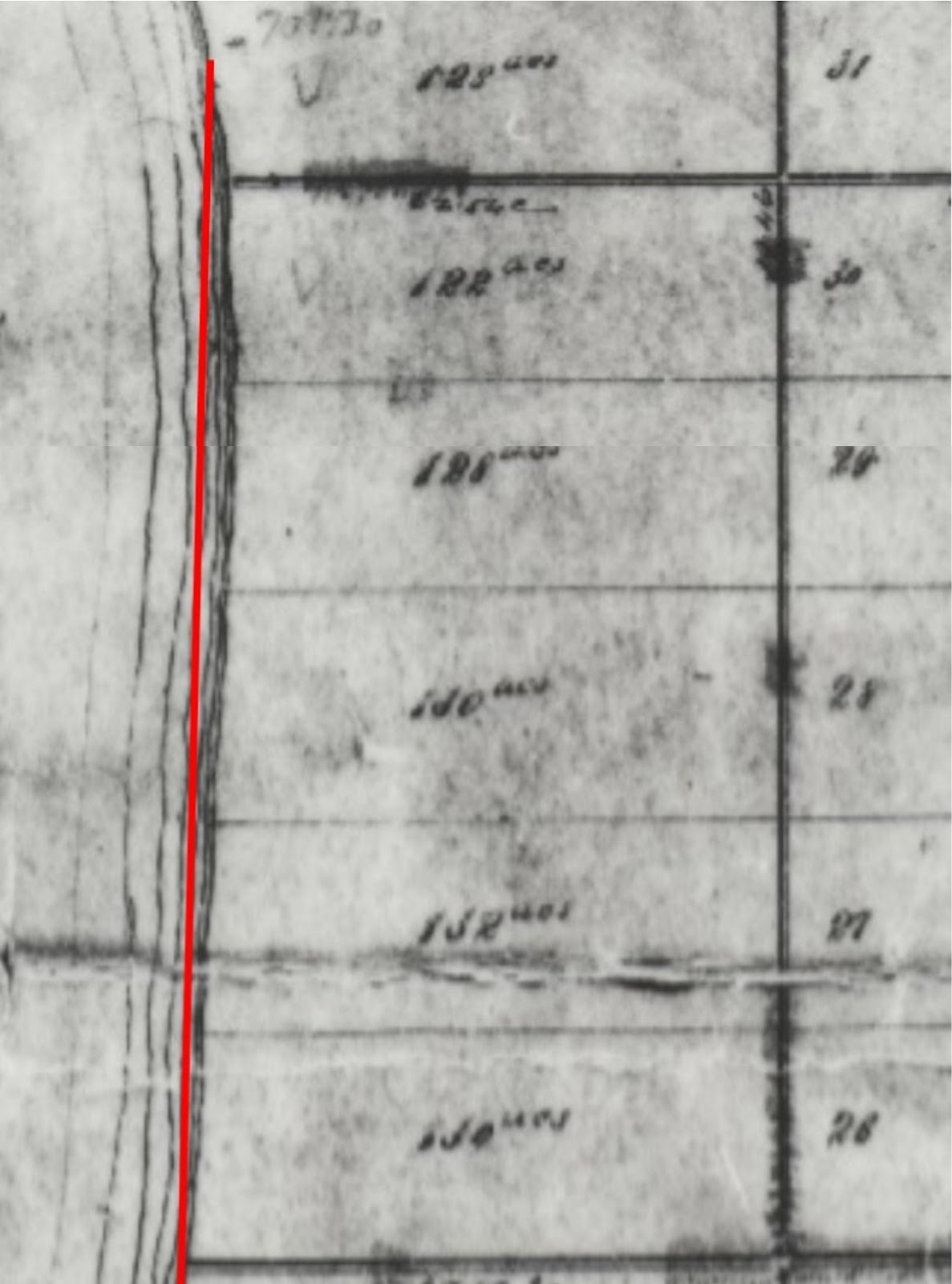
With that little sliver of land in mind, I realized that no one had illustrated the line extension on the official map of 1856 to see if it still would pass through lot 26. I thought it would be well worth a look.

As you can see above on the official map of 1856, if you were to extend the Saugeen eastern boundary past Main Street it would all be in the water from lot 26 to 31. This would prove that the sliver of land was not meant to exist into lot 26. If you try this experiment in Microsoft Publisher you will see how evident it is that the line is in the water the more you zoom in.
Illustration 3 - Number three as follows:
Pros:
Pros:
I wasn't totally satisfied with the accuracy of my results using my copy of the 1856 official map because there is that word in the description of Amabel lots: "about 20 ch." I felt a little unsure about publishing these results, so before I did, I wanted to find a copy of the 1856 map that was to scale. I contacted Natural Resources Canada to inquire about purchasing a copy of the map from their Canada Lands Survey System. They in turn suggested I contact World of Maps located in Ottawa. After a few back and forth e-mails, Brad from WOM's suggested I use the website https://www.ontario.ca/page/topographic-maps to allow for accurate measurements for my specific needs. I didn't realize this website existed, but it sure proved to be exactly what I needed to verify my work.
Let's examine the distances using the Ontario website. I'm sure there will be those who say that you can't use todays measurement results because the shoreline has changed over time, but according to my results, I would argue that, if it has, it hasn't changed much.
Also, if you go on the website you will notice that there have been changes to the western boundary. To accommodate this change, you need to locate the ravine (which is still there) and create a line north, parallel to the eastern boundary, that goes to the shore of Lake Huron.

Illustration 1 - The above result speaks for itself.

Illustration 2
When I tried to zoom in to show the entire length of this distance, the result of 9.78 disappeared, so I created two illustrations to show that I correctly measured the appropriate distance. This website proved to be a great tool to achieve the most accurate answer. I followed the shoreline as fairly as I thought was appropriate without following every little bump and indent. Like I said before: how could you possibly know exactly how close you should follow the shoreline to give the most accurate answer?

Illustration 3 - The result of this answer also speaks for itself.
I did not include example 4 because it seemed to be as far off the mark as example 5 and 6.
It would seem to me, that it comes down to the above three examples that are even in the ballpark for consideration for argument. However, I have already discussed the problems with example 2 and 3. Also, by using the Ontario website, it allows for a more accurate shoreline measurement leaving very little difference in distance between example 1 and 2.
I am admittedly disappointed by the result of the shoreline measurement. Not because it is close to the treaty description of 9 1/2 miles, but because, since it is close, the facts of why it isn't possible are ignored. It is simply not possible, by the wording of Treaty 72 for example 2 to be credible. Once again you cannot ignore these facts:
Don't take my word for it. Please visit the Ontario website and try the measurements for yourself. I can guarantee you that if you place the western boundary in the right place everyone will get the same answer for the measurement of example 1 and 3. However, I will also guarantee you that there will be any number of answers for the measurement of the contours of the shoreline. They will all be fairly close, but different just the same.
Note: There is a little trick to following the shoreline for an accurate measurement on the Ontario website. Rather than measuring the shore with short completed lines, just single click as you follow the shore and continue on until you have completed the entire contour. Then double click at the end to complete the entire outline...You'll see.
NOTE: Please visit the following two postings for updated information in regard to the 9 1/2 mile measurement.
https://saublelandclaim.blogspot.ca/2017/11/nine-and-half-mile-addendum-copway-road.html
https://saublelandclaim.blogspot.ca/2017/11/the-copway-road-theory-vs-some-of-truth.html
The treaty description is as follows with the ambiguous text highlighted in yellow:
"For the benefit of the Saugeen Indians we reserve all that block of land bounded on the west by a straight line running due north from the River Saugeen, at the spot where it is entered by a ravine immediately to the west of the village, and over which a bridge has recently been constructed, to the shore of Lake Huron; on the south by the aforesaid northern limit of the lately surrendered strip; on the east by a line drawn from a spot upon the coast at a distance of about (9 ½ ) nine miles and a half from the western boundary aforesaid, and running parallel thereto until it touches the aforementioned northern limits of the recently surrendered strip;"
To be fair, I wanted to measure every possible interpretation from Treaty 72 that could be made. I, myself, believe that there is only one interpretation that is completely logical, but for sake of argument, I will list all six and examine four. I will list them in no specific order:
- The distance from the SW boundary to the East boundary in a straight line from where the East boundary first encounters the coast of Lake Huron at Main Street.
- The distance from the NW boundary along the shoreline of Lake Huron to the NE < Ind. Res. notation.
- The distance from the NW boundary to the NE < Ind. Res. notation in a straight line.
- The distance from the SW boundary to the NE < Ind. Res. notation in a straight line.
- The distance from the SW to the NW of the western boundary and then follow the shoreline to Main Street.
- The distance from the NW boundary to Main Street.
(I didn't include number 5 and 6 because, while they are possible as an interpretation, they are the most unlikely and not really worth discussing.)


Illustration 1 - Evidence would suggest that number one is the actual instruction used by Rankin to create the NE point of the Saugeen boundary. I believe this first choice is the most logical for the following reasons:
Pros:
- Every map Rankin produced shows the northern limit of the East boundary terminating at the dividing line of lot 25/26. This includes a map that was drawn before the draft map of 1855.
- The East boundary runs parallel to the West boundary. The East boundary first encounters the coast at the dividing line of lot 25/26
- The actual measurement is close to 9 1/2 miles at 9.13 miles which could be interpreted as "about" 9 1/2 miles.
- By the wording of the treaty, one would infer that the measurement should follow a straight line.
- It is the most accurate way to apply the instruction of the treaty in regard to the wording because of the eastern boundary crossing "the coast" at lot 25/26. One would infer that this is the "spot upon the coast" since there is no other spot on the coast within a 9 1/2 mile measurement that could include just land in the boundary. It is specified in the treaty as "all that block of land."
- The treaty does not specify whether the measurement should be taken from the South or the North limit of the western boundary which allows for this interpretation.
- There is very little wrong with this explanation, but if you were to look for one, the wording of the treaty probably should have said "about 9 miles." However, the ambiguities of this argument that require explanation are none.
Illustration 2 - On the surface number two appears to be the best argument but there are undeniable, significant problems:
Pros:
Pros:
- The measurement from a to b is the closest to the 9 1/2 miles stated in the treaty at 9.6 miles.
- The NE < Ind. Res. notation is ambiguous enough at first glance that without further investigation it makes this argument a possibility
- It is unnecessary to specify the NW or SW boundary since the shoreline would have to follow from the NW boundary.
- If the measurement line was not meant to be a straight line the wording of the treaty would most likely signify this fact. Perhaps by saying "on the east, from a spot on the coast that follows the shoreline of Lake Huron from the western boundary aforesaid." After all, the shoreline already exists, why would you give the instruction of "draw a line" rather than the instruction "that follows the shoreline"? If I was to ask you to draw a line from point A to point B without further instruction, you would most likely think that I expect a straight line. By the wording of the treaty, one would infer that the measurement should follow a straight line.
- Although you would know where to start, you would still have the problem of needing to stop at Main Street where the eastern boundary first meets water as you head north. The fact that following the contour of the shoreline produces the closest measurement to 9 1/2 miles does not change the fact that the eastern boundary, being parallel to the western boundary, would still run through the water from lot 26 to 31. You can't have two eastern boundaries from lot 26 to 31. Treaty 72 says the eastern boundary is parallel to the western boundary and therefore it cannot run the contour of the shoreline from lot 26 to 31. No matter how you cut it, if the eastern boundary is to run parallel to the western boundary; the shoreline has no significance from lot 26 to 31 since it is east of the parallel line with only the water of Lake Huron in between. It comes back to the "all that block of land..." argument.
- Even if you ignore the problem described in number 2 and insist that the eastern boundary follows the shoreline, how do you determine the width of the eastern boundary from lot 26 to 31? Is it a pencil width or 10 feet? 100 feet? 2000 feet? There is only one line to work with. The other line is running through the water! How could you possibly determine a width of the eastern boundary at the shoreline from lot 26 to 31?
- How accurately do you follow the shoreline? If you were to follow the shore to every single indent and contour in real size, you would get an answer of more than 9.6 miles. Measuring with a chain along the shoreline of the actual map also doesn't allow for small inaccuracies and inconsistencies.
- All Rankin maps show the termination of the Saugeen Reserve boundary at the dividing line of lot 25/26 indicating that the SW to Main Street measurement of 9.13 miles is the "about" 9 1/2 miles.
- If midpoint lot 31 is meant to be the "spot on the coast" it does not create a NE angle with anything because of the fact the eastern and western boundaries of the reserve run straight and parallel. You only have the curve of the shoreline to create an angle. You need two lines to create an angle. This leaves the notation NE < Ind. Res. without meaning if you relate it to a boundary identification.
- Other evidence suggests that the NE < Ind. Res. notation is related to work that was being performed or was to be performed at Chief's Point.
- The ambiguities tied to this argument that require explanation are too many for this to be considered a valid argument. Not to mention that the required explanations to make it a valid argument cannot be achieved. No matter how appealing this argument appears on the surface, it just cannot be verified mathematically or through simple logic.

(Note: to be honest, I am not totally sure if INAC is supporting argument 2 or 3, but I have heard of the shoreline argument, so I did the measurement. I don't remember INAC explaining either possibility at the meetings of 2014 in regard to how the 9 1/2 mile measurement was achieved.
I am also sure that some have noticed that on the draft map of 1855 it appears that the Saugeen Boundary includes a very small portion of lot 26, but following the actual survey field notes have the eastern boundary starting just inside of Lot 25 where the Gift Bowl is today. This would explain why they may have put in the caveat of "about 9 1/2 miles" in the treaty wording. This way they could clean-up any ambiguous boundary lines at Main Street to terminate the NE corner of the Saugeen boundary. Remember, this is a draft map, not the final map.
With that little sliver of land in mind, I realized that no one had illustrated the line extension on the official map of 1856 to see if it still would pass through lot 26. I thought it would be well worth a look.
As you can see above on the official map of 1856, if you were to extend the Saugeen eastern boundary past Main Street it would all be in the water from lot 26 to 31. This would prove that the sliver of land was not meant to exist into lot 26. If you try this experiment in Microsoft Publisher you will see how evident it is that the line is in the water the more you zoom in.
Pros:
- The NE < Ind. Res. notation is ambiguous enough at first glance that without further investigation makes this argument a possibility.
- The treaty does not specify whether the measurement should be taken from the South or the North of the western boundary allowing for interpretation.
- By the wording of the treaty one would infer that the measurement should follow a straight line.
- measurement = 8.7 miles
- At the time of the survey the eastern boundary would be in the water from lot 26 to 31.
Pros:
- Same reasons as in number three.
- measurement = 10 .4 miles
- At the time of the survey, the eastern boundary would be in the water from lot 26 to 31
I wasn't totally satisfied with the accuracy of my results using my copy of the 1856 official map because there is that word in the description of Amabel lots: "about 20 ch." I felt a little unsure about publishing these results, so before I did, I wanted to find a copy of the 1856 map that was to scale. I contacted Natural Resources Canada to inquire about purchasing a copy of the map from their Canada Lands Survey System. They in turn suggested I contact World of Maps located in Ottawa. After a few back and forth e-mails, Brad from WOM's suggested I use the website https://www.ontario.ca/page/topographic-maps to allow for accurate measurements for my specific needs. I didn't realize this website existed, but it sure proved to be exactly what I needed to verify my work.
Let's examine the distances using the Ontario website. I'm sure there will be those who say that you can't use todays measurement results because the shoreline has changed over time, but according to my results, I would argue that, if it has, it hasn't changed much.
Also, if you go on the website you will notice that there have been changes to the western boundary. To accommodate this change, you need to locate the ravine (which is still there) and create a line north, parallel to the eastern boundary, that goes to the shore of Lake Huron.

Illustration 1 - The above result speaks for itself.

Illustration 2
When I tried to zoom in to show the entire length of this distance, the result of 9.78 disappeared, so I created two illustrations to show that I correctly measured the appropriate distance. This website proved to be a great tool to achieve the most accurate answer. I followed the shoreline as fairly as I thought was appropriate without following every little bump and indent. Like I said before: how could you possibly know exactly how close you should follow the shoreline to give the most accurate answer?

Illustration 3 - The result of this answer also speaks for itself.
I did not include example 4 because it seemed to be as far off the mark as example 5 and 6.
It would seem to me, that it comes down to the above three examples that are even in the ballpark for consideration for argument. However, I have already discussed the problems with example 2 and 3. Also, by using the Ontario website, it allows for a more accurate shoreline measurement leaving very little difference in distance between example 1 and 2.
I am admittedly disappointed by the result of the shoreline measurement. Not because it is close to the treaty description of 9 1/2 miles, but because, since it is close, the facts of why it isn't possible are ignored. It is simply not possible, by the wording of Treaty 72 for example 2 to be credible. Once again you cannot ignore these facts:
- Since the eastern boundary runs parallel to the western boundary, the eastern boundary would be in the water of Lake Huron from lot 26 to 31.
- Even if you ignore fact number one and insist the boundary follows the contour of the lake, there is nothing east of the shoreline to create a width to the eastern boundary from lot 26 to 31. How would you establish a width using this argument?
- Still insisting on the contour argument, because of fact number 2, there is only one curving line on land to work with making the NE < Ind. Res. meaningless in relation to a boundary marker. How do you create a NE angle with one curving line?
- There are other explanations as to what the NE < Ind. Res. notation means that do not support the contour of the lake measurement argument.
- The treaty wording implies a measurement that is in a straight line for the "about" 9 1/2 mile distance.
- Using the more accurate Ontario website for measuring, you cannot ignore that the SW to Main Street argument is almost as close as the contour argument in regard to the 9 1/2 measurement. It also requires no explanations to make up for ambiguities or nonsense.
- You also cannot ignore the fact that Main Street is exactly where Rankin placed the NE termination of the Saugeen Reserve boundary.
Don't take my word for it. Please visit the Ontario website and try the measurements for yourself. I can guarantee you that if you place the western boundary in the right place everyone will get the same answer for the measurement of example 1 and 3. However, I will also guarantee you that there will be any number of answers for the measurement of the contours of the shoreline. They will all be fairly close, but different just the same.
Note: There is a little trick to following the shoreline for an accurate measurement on the Ontario website. Rather than measuring the shore with short completed lines, just single click as you follow the shore and continue on until you have completed the entire contour. Then double click at the end to complete the entire outline...You'll see.
NOTE: Please visit the following two postings for updated information in regard to the 9 1/2 mile measurement.
https://saublelandclaim.blogspot.ca/2017/11/nine-and-half-mile-addendum-copway-road.html
https://saublelandclaim.blogspot.ca/2017/11/the-copway-road-theory-vs-some-of-truth.html
This is good stuff. I agree with you - interpretation number 1 is the right one.
ReplyDeleteCraig Gammie
I don't even know how I ended up here, but I thought this post
ReplyDeletewas good. I do not know who you are but certainly you're going
to a famous blogger if you are not already ;) Cheers!
I think this is among the most important info for me.
ReplyDeleteAnd i am glad studying your article. However should statement on few common things, The website taste is ideal, the articles is in point of fact great :
D. Good job, cheers
This paragraph will assist the internet viewers for setting up
ReplyDeletenew weblog or even a blog from start to end.
Asking questions are in fact good thing if you are not
ReplyDeleteunderstanding something entirely, however this post provides fastidious
understanding yet.