Even so, the shoreline measurement belief has bothered me for quite sometime, but an answer to this has also been kicking around in my head for sometime. So, if a weak case can be made for the reserve to extend further north to mid lot 31, a very strong and even more compelling argument can be made for why the reserve boundary was not positioned there even if the NE < Ind. Res. notation was intended to mark the spot on the coast. Let me explain:
Throughout the examination of this case very little mention has been made of the amendment made to Treaty 72 in September of 1855. The amendment is as follows: (Item 1 of the amendment is all that is relevant to the land claim)


With this amendment in mind I started wondering what each shoreline measurement added up to. Using the Ontario Topographic Map website tool, I decided to measure two distances: 1.) the NW position of the original western boundary to the midpoint of lot 31 and 2.) the distance from the beginning position of the amendment (where Copway Road meets Lake Huron) to Main Street Sauble Beach. I also decided to make these measurements in two different ways 1.) Following every contour and indentation of the shoreline from point A to point B and 2.) just following the shoreline in a reasonable manner to what might be expected from point A to point B. The results are telling.
Let's assume that everything that INAC and the Saugeen Band have been preaching is the gospel truth. That is, the 9 1/2 mile measurement was initially intended to run from the NW position of the western boundary to the NE < Ind. Res. notation at midpoint lot 31 following the shoreline. Here's how the two measurements look. First the "every contour" example:

Using every contour the distance equals 10.23 miles which isn't even close to 9 1/2 miles. So, I used a less demanding and more reasonable representation of how the shoreline measurement would have probably been conducted and came up with this result. (Let me comment here that I made all these measurements once and didn't tinker with them until I came up with the desired outcome.)

The result is 9.64 miles which is very close to the "about 9 1/2 miles" from the treaty instruction. So, if the 9 1/2 mile measurement was supposed to originate from the NW position of the original western boundary as stated by INAC it is very close to 9 1/2 miles as they have contended.
BUT WAIT!!
With the amendment there is a new position for the NW position of the western boundary where the 9 1/2 mile measurement should be taken from. Rankin stated that the terms of the treaty would not be altered in any way, so the measurement has to begin from the new location.
The same method used to measure distance above look like this using the Amendment to Main Street positions. First the every contour map:

The every contour measurement equals 10.29 miles. So, let's check out what the "reasonable following of the shoreline measurement" comes out to.

The measurement from the amended boundary to Main Street equals 9.59 miles. Using this logic and considering every Rankin map shows the Northern most point of the Saugeen Boundary at Main Street, proves that the 9 1/2 measurement was taken from the amended NW position of the western boundary NOT the original NW position of the western boundary as written in the original text of the treaty. The fact the two distances are almost exactly the same is further proof.
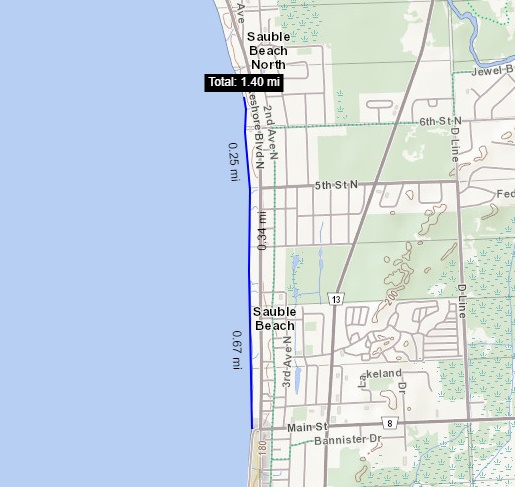
To check my research I measured the distance from the original NW boundary from the Treaty to the amended NW boundary. I then measured the distance from mid point Lot 31 to Main Street. The distances are exactly the same at 1.4 miles. This is not coincidental.


Many of the arguments I have presented seem to have some form of coincidence. I say coincidence since there is no one left alive to prove my logic. I can think of five right off the top of my head:
- Saugeen Band Special Fishery License description = exactly Livingston Huff's description of what he believed to be the Saugeen Reserve from Lot 25/26 to the Sauble River
- Where the extension line of the Saugeen Reserve meets the extension line of Chief's Point eastern boundary on the 1855 draft map a bearing for N 13° W True could be taken. The same bearing reading found on Rankin's 1856 final map.
- From Main Street Sauble Beach to midpoint lot 31 and from the original NW boundary to the amended NW boundary the distance is the exact same at 1.4 miles.
- On the October 12th, 1855 draft map True North bearings are only taken from the physical eastern boundary line of the Saugeen Reserve with one exception; Magnetic North itself. All other bearings use Magnetic North.
- The Saugeen Band actually mention their having given up the position from Lot 31 to Main Street in the Band minutes from 1883 even though they refer to it as the Sauble Fishing Station which ran all the way along the shore from lot 25/26 to the Sauble River.
Since all we can do is speculate on what happened why not use the logic gathered? What seems most likely is this:
The position on the coast for the Saugeen Reserve's NE point possibly was to extend to lot 31. However, when Rankin traversed from the Sauble River to Lot 25/26 he found that it was not possible for the reserve to extend to lot 31 since it would be running through the water of Lake Huron, considering the eastern boundary ran parallel to the western boundary. Rankin documented during discussion of the Copway Amendment that the Saugeen Band believed they agreed that the NW position of the western boundary was to begin at Copway Road which was a dirt path that ran from the shore of Lake Huron to the Native village. Logic dictates that since it was impossible to continue the reserve to lot 31, the northern point of the reserve was located at Lot 25/26 (Main Street) because it is the first intersection where land meets water to identify the "spot on the coast." The Saugeen Band were upset they were losing 1.4 miles of frontage that they thought they had agreed to in the treaty. They disputed this, and the southern portion along the shore of Lake Huron was increased by 1.4 miles which also increased the area of land for the reserve which was also noted in the amendment. (It is notable that this comment was made about increased frontage in the amendment since frontage could not exist in regard to the Saugeen Reserve boundary from Main Street to midpoint Lot 31.) By following the angle of the Copway Road to the shore of Lake Huron the Saugeen Band actually increased the reserve size rather dramatically compared to receiving nothing since it was impossible to locate the NE corner at lot 31.

As logical as this explanation is there is still one piece of evidence that I intentionally omitted in my list above and it is proof the 9 1/2 mile measurement originated from the NW position of the amended western boundary. The proof is this:
- Rankin's Grey/Bruce map of January 1855 already placed the NE boundary limit of the Saugeen Reserve at the same point, before the western boundary dispute, as Rankin's final map of 1856. The location is Lot 25/26 or more commonly known as Main Street. You may remember that this was established by measuring the distance between the NE boundary limit of the Saugeen Reserve and the mouth of the Sauble River. Both measurements were the same on each map. Since these distances are the same with one predating the Oct. 12th, 1855 draft map and one post dating it, the INAC/Saugeen Band argument doesn't hold up.

The only possible explanation for this which also doesn't help the INAC/Saugeen Band theory is that although the draft map was dated October 12th, 1855 it probably existed well before this date. Perhaps the NE < Ind. Res. notation was one of the first entries made on the map and was entered while discussions were ongoing about the details of the treaty. As I said, Rankin may have made the notation before he realized the True North line would run through the water of Lake Huron from Lot 31 to Lot 25/26. Even if the notation was entered on the map later it may have only be entered as a reference point to what initially was believed to be the reserve limit and not the reserve limit itself. Perhaps to actually show how the lot 31 position is impossible to achieve.
Imagine this: The October 12th, 1855 draft map without the grid of lot lines, revealing only the lines of known physical features such as rivers, lakes, shorelines and other know man-made lines such as the recently surrendered strip. Imagine that the eastern boundary of the Saugeen reserve is not yet on the map. Imagine discussion of where the NE point of the Saugeen reserve might be and making note of it on the map before the True north line is established. Actually measuring out the 9 1/2 mile distance by boat until reaching what would become the midpoint of Lot 31 to mark "the spot on the coast." Then imagine discussion taking place when Rankin discovers that the intended position of the NE boundary limit of the Saugeen Reserve is impossible because of the positioning of the eastern boundary. (Perhaps Rankin realized the error while making the Grey/Bruce map, but did not comment until he verified it in the field) Imagine a compromise and amendment being made which would include the same amount of shoreline to the south that would make up for the distance to be lost to the north.
Does this sound so fantastical? If so, the mystery of the NE < Ind. Res. notation may never be revealed. Was it Rankin that even made the notation? He did not sign the October 12th, 1855 draft map. Examine the notation closely. The NE < Ind. portion of the notation appears to be written by the same hand, but the Res. portion is written in cursive which appears to have been added by someone else. I'm not sure if this is significant, but the Res. part of the notation also appears to be written over top of the lot line indicating the notation was written after the lot line grid was drawn or at least the "Res." portion of the notation was. How can this be explained? Whatever the explanation the "Res." portion is different from the rest of the notation.

The Copway Road Amendment Theory makes sense. It actually tracks a timeline for the treaty from start to finish that is logical. It also may explain why the Band made the comment they did in their Band minutes from 1883: "that John Creighton, our Indian agent be and is hereby requested to ask the Department to have Sauble Beach Fishing Station given back to this Band." Again, how can it be ignored that this statement is recorded in the Band minutes? It fully acknowledges that the Band has surrendered that portion of land.
The Copway Road Amendment Theory holds very little speculation compared to the theory of INAC/Saugeen Band. Their theory simply states the measurement from the original NW boundary to the NE < Ind. Res. notation is 9 1/2 miles along the shoreline therefore that is where the Reserve is supposed to end. End of story. But that isn't the end of the story.
One thing that I do know is that the number of coincidences, facts and arguments that counter the one argument made by INAC and the Saugeen Band leave their one argument impossible to prove and the least tangible among all other possible arguments we have available. I contend that if the shoreline measurement is indeed the measurement used, then whereever the amended boundary was relocated, 9 1/2 miles from that point would mark the NE corner of the Saugeen Reserve. In other words if the Copway Road had been 3 miles south of the original NW boundary than the NE corner of the Saugeen Reserve would have been 9 1/2 miles from that point. It is not a coincidence that 1.4 miles is the distance between Main Street and Lot 31 and that 1.4 miles is the distance between the original NW boundary and the amended NW boundary. It is also not a coincidence that the NW position of the western boundary to Lot 31 and the NW position of the amended western boundary to Lot 25/26 (Main Street) are both 9 1/2 miles. What stands out about the Copway Road Amendment Theory is this:
- The impossibility of the NE corner of the Saugeen Reserve extending to midpoint Lot 31 from Main Street was apparent in 1855. When the Saugeen Band disputed the placement of the original western boundary, it was a "no contest" to honour the 9 1/2 mile measurement commitment made in the treaty by approving the Copway Road amendment.
- The distance from Main Street to midpoint Lot 31 and the original NW boundary to the amended NW boundary being the same shows that the concerns of the Saugeen Band had been addressed and they were not cheated out of land that they should have had as stated in Treaty 72. It actually increased.
- The distance between the amended position at Copway Road and Lot 25/26 or Main Street is almost exactly 9 1/2 miles if you make the measurement following the shoreline of Lake Huron. This is what the Saugeen Band claimed they originally agreed to in the first place.
The innumerable scenarios available to examine the facts of this seemingly simple land claim continue to surprise me, but I feel this posting may complete my research. I believe that every other previous discovery within this blog is of equal importance and helped lead to the conclusion of this theory. There was only one rock left unturned and that was how to explain why the measurement along the shoreline from the NW position of the original western boundary to midpoint Lot 31 is the closest to 9 1/2 miles. It could not be denied that it was, so I felt it was imperative to meet it head on even if it meant conceding, in part, that the INAC theory has some elements of truth. I think the Copway Road Amendment explanation does a fairly concise job of explaining the 9 1/2 mile measurement, perhaps even conclusive. That is, of course, if following the shoreline was indeed how the measurement was conducted.
No comments:
Post a Comment